Connacht (West Coast / Wild Atlantic Way)
Wild Atlantic Way
Ireland's 2,500km signed west-coast drive, from Donegal to West Cork: how to break it into stages, where to start, real drive times and whether to do the whole thing or just a slice.
In short
Wild Atlantic Way at a glance
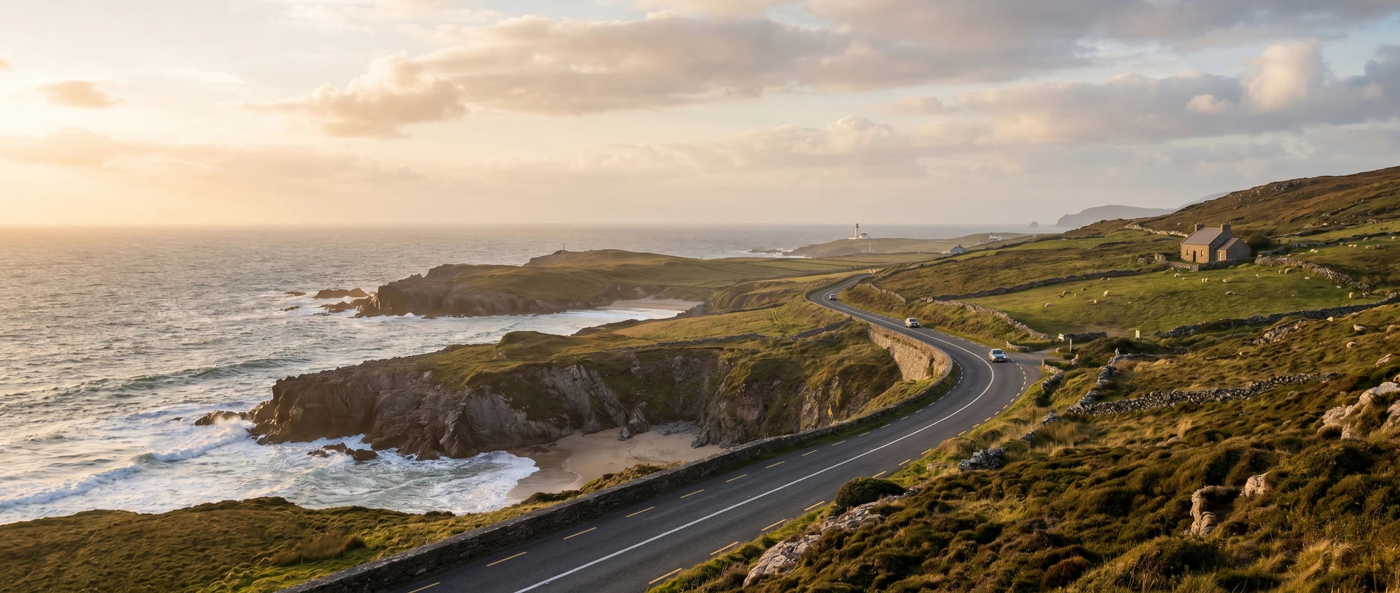
The Wild Atlantic Way is a single 2,500km signed touring route hugging Ireland's entire west coast, from Malin Head in Donegal down to Kinsale in West Cork, split into 14 official stages. The honest truth nobody tells you: almost no UK visitor drives the whole thing. The full route is about 32 hours behind the wheel and wants 11–14 days; most people fly into Shannon, Cork or Knock and drive one rich slice — Clare and Kerry in the south, or Galway, Connemara and Mayo in the middle. It's a left-hand-drive country like home, which strips out the usual hire-car nerves, but the coast roads are narrow and single-track in places, so the route is about pacing, not pace. Pick a section, base yourself somewhere central, and let the signs (a blue zigzag wave) do the navigating.
The Wild Atlantic Way is one continuous touring route — 2,500km of signed coast road running the full length of Ireland’s western edge, from Malin Head at the top of Donegal down to the harbour town of Kinsale in West Cork, split into 14 official stages. The thing to understand before you book anything is that almost nobody drives the whole thing. The complete run is around 32 hours behind the wheel and wants 11–14 days; what most UK visitors actually do is fly into Shannon, Cork or Knock and drive one rich slice over five to seven days, following the blue zigzag-wave signs that mark the route in both directions.
The good news is that this is the easiest foreign road trip a UK driver can take: Ireland drives on the left like home, so there’s no wrong-side learning curve, just narrow, hedge-lined coast lanes that are slower than the map promises. The two slices worth choosing between are the Clare–Kerry south — the Cliffs of Moher, the Burren, the Dingle Peninsula and the Ring of Kerry — and the quieter Galway–Connemara–Mayo middle, where Achill Island’s Keem Bay and the empty bogland of Connemara see a fraction of the coach traffic. Go further north into Donegal and you get the wildest stretch of all, including the Slieve League cliffs, which at 601m are nearly three times the height of the famous Cliffs of Moher and a tenth as busy.
A few specifics make the drive smoother. Going north-to-south keeps you on the seaward side of the road for the best views and the easiest pull-ins. Between Clare and Kerry, take the 20-minute Killimer–Tarbert car ferry across the Shannon Estuary (about €23 one way, roughly hourly) — it’s the only vehicle ferry on the route’s main spine and saves around two hours over driving inland. And go in May, June or September: the west coast is at its driest and brightest then, with daylight until 22:30 in midsummer and far fewer cars than the July–August peak. Whatever the month, pack a proper waterproof — the weather here changes by the hour.
The route
The Wild Atlantic Way isn't an itinerary, it's a 2,500km menu. The full north-to-south run from Malin Head to Kinsale is roughly 32 driving hours and realistically needs 11–14 days; below is that complete skeleton so you can see the shape. But the smarter UK trip is to fly into Shannon, Cork or Knock and drive one of the middle blocks well over 5–7 days — the Clare–Kerry south or the Galway–Connemara–Mayo middle — rather than rushing the lot. Drive times are coast-road estimates: the distances look short, but single-track lanes and the views you'll stop for make them slower than the map suggests.
-
Days 1–2
Donegal: Inishowen & Slieve League
Start at the very top — Malin Head on the Inishowen Peninsula is the northernmost point of mainland Ireland and a dark-sky spot for the Northern Lights. Drive south-west to the Slieve League cliffs (601m, nearly three times the Cliffs of Moher and far quieter), basing in Ardara or Donegal Town. This is the route's wildest, least-touristed stretch.
-
Days 3–4
Sligo, Mayo & Achill Island
South through Sligo (surf beaches and Yeats country) into Mayo. The highlight is Achill Island, reached by bridge: drive the Atlantic Drive and the hairpin road down to Keem Bay, a horseshoe beach under Croaghaun's 688m cliffs — the highest in Ireland. Base in Westport, the prettiest town on this stretch.
-
Days 5–6
Connemara & Galway
Loop through Connemara — bog, mountains and the harbour town of Clifden — then into Galway city, the route's natural hub and the best small-city night out in Ireland. Galway is your refuelling stop: walkable, full of music pubs and seafood, and well connected to Knock and Shannon airports.
-
Days 7–8
Clare: the Burren & Cliffs of Moher
South into County Clare for the Burren's grey limestone moonscape and the Cliffs of Moher (214m; entry is ~€10 per adult on the gate, about €7 (~£6) if you book online, and that covers the car park and visitor centre — go early or late to dodge the coach crowds). Doolin makes a good base and is the trad-music capital. Loop Head, further south-west, is the quieter cliff alternative.
-
Day 9
Killimer–Tarbert ferry into Kerry
Take the 20-minute car ferry across the Shannon Estuary from Killimer to Tarbert (~€23 / around £20 one way, hourly) — it's the only vehicle ferry on the route's main spine and saves about two hours versus driving inland around Limerick. You land in north Kerry; push on to Killarney or Dingle.
-
Days 10–11
Kerry: Dingle & the Ring of Kerry
The postcard finish. Drive the Dingle Peninsula's Slea Head Drive (quieter and arguably more dramatic than the Ring of Kerry) and the 180km Ring of Kerry itself — go anticlockwise so you don't meet the tour coaches head-on. Base in Killarney or Dingle town.
-
Days 12–14
West Cork to Kinsale (the finish)
The gentle final leg: the Ring of Beara, Mizen Head (Ireland's south-westerly tip) and the harbour town of Kinsale, where the route officially ends. Softer, greener and warmer than the wild north — a fitting wind-down before flying home from Cork.
Where to base yourself
Pick one or two bases rather than moving every night.
Galway city
££ mid-rangeThe route's natural middle hub and the best base if you're doing the central section. Walkable, packed with music pubs and seafood, and the launchpad for Connemara, the Burren and the Cliffs of Moher. Book well ahead in summer and on festival weekends, when the city fills up fast.
Best for: The Galway–Connemara–Mayo middle section
Killarney (County Kerry)
££ mid-rangeThe tourist-friendly hub of the south-west: a compact town on the edge of Killarney National Park and the start of the Ring of Kerry, with easy parking and plenty of guesthouses. The obvious base for the Kerry stages and a Dingle day.
Best for: The Clare–Kerry south section
Westport (County Mayo)
££ mid-rangeThe prettiest planned town on the route and the natural base for Achill Island and Clew Bay. A lively, walkable centre with good food and the Great Western Greenway cycle path on its doorstep — a quieter, more local-feeling stop than Galway.
Best for: Achill, Mayo and the central-north stretch
Donegal Town / Ardara
££ mid-rangeYour base for the wild northern stages and Slieve League. This far up the route is the least touristed and the most weather-exposed, so rooms are fewer and you'll want a flexible plan — but it's the most dramatic, empty scenery of the lot.
Best for: The Donegal far-north section
Kinsale (County Cork)
££ mid-rangeThe route's official southern end: a colourful harbour town with a reputation as Ireland's gourmet capital and an easy 30-minute hop to Cork Airport. The softest, warmest stretch of the whole drive — a good place to start or finish if you fly into Cork.
Best for: Starting or finishing via Cork Airport
Getting around Wild Atlantic Way
A hire car is close to essential — the Wild Atlantic Way is built for driving and public transport barely reaches most of it. The good news for UK travellers: Ireland drives on the left like home, so there's no wrong-side learning curve, just narrow, hedge-lined, often single-track coast roads that take longer than the map suggests (pad every estimate). Pick the car up at your arrival airport — Shannon is the handiest for Clare and Kerry, Cork for the south, Knock or Galway for the middle — and consider a one-way hire so you don't backtrack to return it (expect a one-way surcharge). The one ferry on the main spine is the 20-minute Killimer–Tarbert crossing of the Shannon Estuary (~€23 / around £20 one way, hourly, a couple of euro cheaper booked online), which cuts about two hours between Clare and Kerry. Fuel is dearer than the UK, and the route is signed both directions with a blue zigzag-wave symbol, so you barely need the sat-nav once you're on it.
Book the essentials
Where to stay
Tours & tickets
Airport transfers
Car hire
Stay connected
Wild Atlantic Way FAQs
How many days do you need to drive the Wild Atlantic Way?
Which is the best section of the Wild Atlantic Way?
Should you drive the Wild Atlantic Way north to south or south to north?
Do you need a car for the Wild Atlantic Way?
What is the best time to drive the Wild Atlantic Way?
Is the Killimer–Tarbert ferry worth it?
Ready to book?
Compare car hire